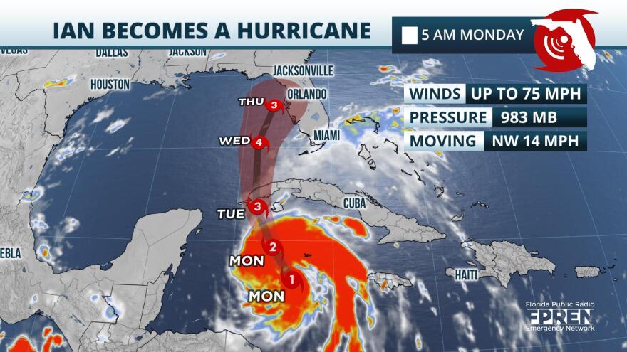
In the eastern Caribbean Sea, Ian strengthened into a hurricane with winds up to 75 miles an hour early on Monday morning. The category one storm is expected to undergo rapid intensification over the next few days, and it could become a major hurricane off Florida’s Sun Coast by midweek.
As of 5 AM Monday, forecasters at the National Hurricane Center said that thunderstorms around Ian’s core organizing and intensifying. In addition, data and imagery products indicated that circulation around the storm was much better developed, and that an eye was beginning to form. Environmental conditions near and ahead of the storm, located in the eastern Caribbean about 300 miles southeast of eastern Cuba, are supportive of continued intensification over the next 24 to 72 hours.
The official forecast from the National Hurricane Center projects Ian to move northward Monday and over the tip of western Cuba early Wednesday. After that, forward speed is projected to slow, and Ian should pass near the Lower Keys late Tuesday into early Wednesday. Toward the end of the week, Ian should parallel the Sun Coast, and after that, landfall is possible anywhere from the Tampa Bay metro northward toward the Nature Coast and Big Bend. Timing of the former scenario would be sometime Wednesday, and the latter, by sometime Friday.
During Ian’s approach to Cuba, it is expected to strengthen into a category two or three storm. After that, the forecast calls for further intensification, and Ian could reach category four strength, with winds over 130 miles an hour, by midweek as it sits off the Lee Island and Sun Coast. Ian is then projected to weaken toward the end of the week, as it enters an environment of increasing wind shear and decreasing relative humidity.

As of early Monday, the following alerts are in effect:
Tropical Storm Warning: The Lower Florida Keys from Seven Mile Ridge to Key West
Tropical Storm Watch: Englewood to Everglades City
Hurricane Watch: Englewood northward to Tarpon Springs… this includes Tampa Bay
Tropical Storm force winds could arrive as early as:
Lower Keys: Before dawn Tuesday
South Florida from the Everglades to Sarasota: Tuesday mid-morning
Central Florida from Sarasota northward: Tuesday evening
North Florida: Wednesday
In addition to hazards posed by winds, Ian is expected to produce life threatening storm surge along the Gulf Coast of Florida. Along the coast and farther inland, tornadoes will be possible as outer bands rotate inland later this week.
It is important to remember that the details of forecast track, impacts, and timing of impacts are likely to continue fluctuate over the next few days. Floridians are urged to continue watching the forecast, and to heed evacuation orders. Find out more about your evacuation zone by visiting floridadisaster.org.
Copyright 2022 Storm Center.

