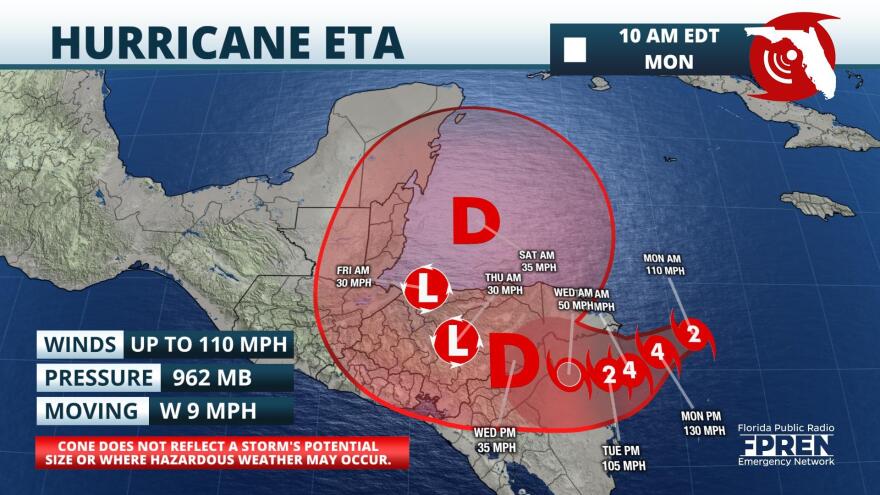
Update as of 10:45am Monday:
Eta continues to rapidly intensify and is now a category 2 hurricane with top winds of 110 mph. It is forecast to become a major hurricane soon and make landfall early Tuesday as an extremely dangerous category 4 hurricane in Nicaragua.
Update as of 7:30am Monday:
Eta strengthened quickly overnight Sunday and is now a hurricane. As of 7 am EST Monday, top sustained winds are near 90 mph and further strengthening into a category 2 hurricane is forecast later Monday. The hurricane is forecast to make landfall on Tuesday in Nicaragua as a category 2 or category 3 hurricane.
Life-threatening storm surge of up to 15 feet is possible in Nicaragua, close to where the hurricane crosses the coast. Eta's slow movement is likely to produce devastating flash flooding in Honduras and Nicaragua, where 2 feet of rain is expected in places. Forecasters at the National Hurricane Center said up to 3 feet of rain is possible in isolated locations.
Eta is not anticipated to be a direct U.S. threat this week. However, Eta's remnant, or a new tropical system, may develop in the northwest Caribbean toward the upcoming weekend. It is too soon to determine whether this new system may have an impact on the Southeast U.S. coastline.
Original story from Sunday:
Tropical Storm Eta formed late Saturday night in the central Caribbean Sea becoming the 28th named storm of the 2020 Atlantic Hurricane Season. Hurricane and Tropical Storm Warnings have been issued for parts of Nicaragua and Honduras where Eta is expected to impact Tuesday.
Favorable environmental conditions, which include minimal vertical wind shear and warm sea surface temperatures, are forecast ahead of Eta which could allow it to strengthen rapidly. Weather models are anticipating Eta to become a hurricane as it impacts Central America.
Eta is expected to be a slow moving tropical cyclone as it approaches the shores of Honduras and Nicaragua late Tuesday. This slow forward movement will increase the flooding concern for portions of Jamaica, the Cayman Islands, and Central America. The storm could produce 5 to 10 inches of rain, with local maximum amounts of 15 inches across Jamaica, the Cayman Islands, and the southern coast of Hispaniola. However, parts of Honduras and Nicaragua could see higher amounts of 10 to 20 inches, with isolated rainfall amounts as high as 30 inches. According to the National Hurricane Center this could be one of the worst flooding disasters since Hurricane Mitch in 1998.
Eta is anticipated to linger near the Central American coast through midweek, thereafter, there is still much uncertainty regarding the path and intensity of the storm. Several weather models are hinting that Eta could redevelop and move northward after impacting Central America. Other models are suggesting another system, separate from Eta, could form in the western Caribbean by the end of the work week and then travel northward. It remains too early to say whether Eta could become a threat to the United States. Coastal residents are advised to closely monitor the situation this week.
The 2020 and 2005 hurricane seasons tie the record for most named tropical cyclones in a single year. This is the first time the name “Eta” has ever been used.
Copyright 2020 WUFT 89.1

