-
 As a nor’easter approaches our region, a coastal flood warning has been issued for much of Northeast Florida through Sunday.
 -
 Significant tidal flooding is expected along the St. Johns River and St. Marys River basins beginning Thursday. Moderate to potentially major coastal flooding is also expected along the First Coast beaches Friday and Saturday.
 -
 Swells from Major Hurricane Sam are expected to reach the coast on Friday and continue into the weekend as it spins well offshore.
 -
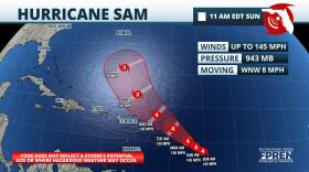
 Hurricane Sam matched Hurricane Ida as the season's strongest hurricane late Sunday, but is forecast to stay at sea.
 -
 Hurricane Sam reached category 4 status late Saturday afternoon. It is the fourth Atlantic hurricane to achieve major hurricane status in 2021.
 -
 Sam rapidly intensified overnight and is forecast to become a major hurricane over the weekend. While models suggests Sam may stay out to sea, it is still too soon to credibly predict whether there will be impacts to Florida.
 -
 Floridians usually have to wait much longer than the first day of autumn for that "fall feel" in the air. That won't be the case this year for those living north of I-4, as a noticeable cold front surges in.
 -
 The Tropical Atlantic has had no shortage of tropical storms in recent days.
 -
 Two days of heavy rain prompted flood watches and warnings across the northern third of Florida this weekend. That heavy rain risk will shift south this week, while the tropics stay active but non-threatening.
 -
 The remnant of what was once Hurricane Nicholas has dissipated over Louisiana, but the moisture out ahead of it remains and will contribute to wet conditions over a large portion of the state this weekend.
Play Live Radio
Next Up:
0:00
0:00
Available On Air Stations


