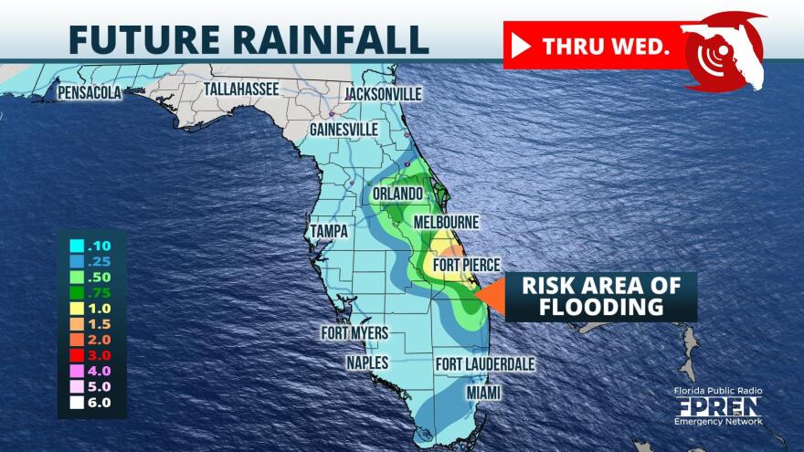
Downpours through midweek could lead to flooding along the coast and in the St. Johns River Basin, especially in flood-prone locations.
Localized flash flooding is possible along the Interstate 95 corridor, potentially slowing down traffic for people traveling ahead of the Thanksgiving holiday.
Surface analysis Monday afternoon depicted a stalled frontal boundary across South Florida and an extended ridge of high pressure across much of the Southeast. These two features will act in tandem through Wednesday to increase onshore flow and bring the risk of locally heavy downpours, especially as a trough of low pressure develops along the east coast Tuesday into Wednesday.
Deep atmospheric moisture will exist across much of eastern and central Florida, resulting in the risk for flash flooding. The Weather Prediction Center depicts a sliver of enhanced flash flood potential along the I-95 corridor Monday into Tuesday, as anomalously high moisture content moves overhead.
One to 3 inches of rain are forecast through Wednesday in coastal areas, though a few locally higher totals will also be possible. Model guidance does depict a modest amount of instability, which could lead to a few rumbles of thunder.
Severe weather does not appear likely as of publishing according to the Storm Prediction Center's outlook on Tuesday. Areas hard-hit by flooding from Ian and additional rains from Nicole should pay close attention to the forecast, as some of these locales will again face the risk of additional flood concerns.
The trough of low pressure should gradually peel away from the coast through Wednesday, tapering off rain chances from west to east through the Thanksgiving holiday. Most locations will be drying out and warming up ahead of the next cold frontal passage, which is likely to occur Friday into Saturday.
Copyright 2022 Storm Center.

