
Jeff Huffman
MeteorologistJeff Huffman is Chief Meteorologist at the University of Florida in Gainesville. In addition to his full-time position at the university's radio and television stations, WUFT-FM/TV and WRUF-TV, the latter of which he co-founded, Huffman also provides weather coverage to public radio stations throughout Florida
-
 Hazards such as heavy rain and potential flooding are still possible on Sunday, but the worst effects from Fred are expected to stay out over the Gulf and head for the Panhandle.
 -
 Tropical Storm and Storm Surge Warnings are now in effect for a large portion of the Florida Panhandle and Big Bend as Fred moves toward the north-northwest.
 -
 Tropical Depression Fred is expected to regain tropical storm strength by the time it approaches Southwest Florida Friday night, and a Tropical Storm Watch over the Keys and Straits of Florida has been upgraded to a Tropical Storm Warning.
 -
 Wind and surge impacts could vary greatly in some places depending on Fred's track, but the greatest hazard to most Floridians will be heavy rain and potential flooding.
 -
 The storm has the potential to affect a large portion of Florida this weekend with heavy rain and high winds, although the magnitude, location and timing of those impacts are still uncertain.
 -
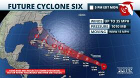 Potential Tropical Cyclone Six will be approaching Puerto Rico Tuesday, then the Florida Straits by week's end.
 -
 Flooding is ongoing in several counties along Florida's Nature Coast, where more rounds of heavy rain are expected through Thursday evening.
 -
 A frontal boundary sliding into the Southeast will begin to enhance thunderstorm activity across North Florida late Thursday and Friday, then...
 -
 Update 8:30 AM EDT Wednesday: Wind gusts to 57 mph have been reported at Cedar Key shortly after 7 o'clock this morning. Tropical Storm and Storm Surge...
 -
 Last updated at 8:55 a.m. Wednesday: Heavy rain is expected to arrive in the Jacksonville area and last through the day today.As of 8:30 a.m., the center…


