-
 Ian remains forecasted to parallel the Gulf Coast before making landfall with the Sun Coast Thursday. Tornado risk increases from I-4 south today.
 -
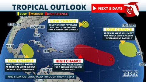 Four areas of tropical development are now being monitored in the Atlantic basin. The most concerning is a large area of low pressure over the central parts where organization into a tropical depression is likely by the middle of the week.


-
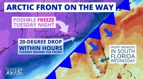 An arctic front will send freezing temperatures deep into the Southeast this week, including portions of the Florida Panhandle by Wednesday morning. The...
 -
An arctic front will send freezing temperatures deep into the Southeast this week, including portions of the Florida Panhandle by Wednesday morning. The...
-
 A short-lived tropical depression is likely to form over the Gulf of Mexico Friday, before merging with an approaching front this weekend. The system is...
 -
 Dorian has strengthened into a hurricane near St. Thomas in the U.S. Virgin Islands and could become a Category 3 storm when it makes its projected...
 -
 More than 85 percent of all hurricane activity in the Atlantic Basin occurs after the middle of August. Some consider Aug. 15 as the “real” start to...
 -
 Update Monday 2:00 PM ET: The tropical wave over the eastern Caribbean Sea is moving slowly west-northwestward and it’s not becoming better organized...
 -
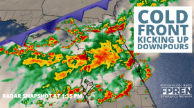 Update 1 pm Wednesday : As of 1 pm the cold front extended through southeast Georgia into North Florida near Apalachicola. Highest rainfall totals are...
 -
 Update 5:00 PM Monday: The season’s third tropical depression has formed between the Bahamas and Florida. The National Hurricane Center says it’s...
 -
 The heart of hurricane season is approaching, and the atmosphere is signaling that the Atlantic Basin could soon become more active. No development is...
 -
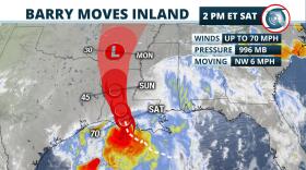 Update 2 pm Saturday: Barry made landfall as a Category 1 hurricane near Intracoastal City, just southwest of Lafayette, Louisiana early Saturday...


