-
Ian remains forecasted to parallel the Gulf Coast before making landfall with the Sun Coast Thursday. Tornado risk increases from I-4 south today.
-
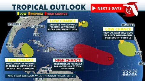
Four areas of tropical development are now being monitored in the Atlantic basin. The most concerning is a large area of low pressure over the central parts where organization into a tropical depression is likely by the middle of the week.
-
A line of thunderstorms capable of producing damaging wind gusts is expected to barrel through Central Florida Wednesday afternoon. A humid air mass is...
-
Multiple rounds of showers and thunderstorms are likely across Florida over the next three days, thanks to a slow-moving front that could produce heavy...
-
A Tornado Watch has been issued for all of north and northeast Florida until midnight. The watch includes the cities of Jacksonville, Gainesville, Ocala...
-
A Tornado Watch has been issued for all of north and northeast Florida until midnight. The watch includes the cities of Jacksonville, Gainesville, Ocala...
-
A Tornado Watch is in effect until 8 PM ET (7 PM CT) for much of the Big Bend and parts of the Florida Panhandle. The watch includes Tallahassee, Panama...
-
Update as of 6:10 AM ET / 5:10 AM CT: The Storm Prediction Center has issued a Tornado Watch from roughly Marianna to Panama City and westward until...
-
Multiple weather-related hazards are possible over a large portion of the Sunshine State Wednesday night and Thursday thanks to a strong storm system...
-
Update as of 9:00 PM Friday: A Severe Thunderstorm Watch is in effect for much of South Florida, including Collier, Monroe, Broward, and Miami-Dade...
-
Millions of Floridians experienced the coldest air in several years Wednesday morning, and in some places, the coldest in nearly a decade. Arctic air...
-
The coldest air mass in two years has engulfed the Florida peninsula, and subfreezing temperatures or wind chills are possible as far south as the...


