-
 Ian remains forecasted to parallel the Gulf Coast before making landfall with the Sun Coast Thursday. Tornado risk increases from I-4 south today.
 -
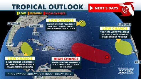 Four areas of tropical development are now being monitored in the Atlantic basin. The most concerning is a large area of low pressure over the central parts where organization into a tropical depression is likely by the middle of the week.


-
A powerful cold front will blast through Florida this weekend, producing possible severe weather and dropping temperatures by nearly twenty degrees in...
-
The storm system that produced severe thunderstorms across portions of Florida Thursday has a mean back side that will sweep across the state Friday....
-
Thursday Afternoon Update A Severe Thunderstorm Watch was issued for much of southeast Florida, including Miami and West Palm Beach, until 9 pm. This...
-
Flooding, high winds, and tornadoes are possible in Florida Thursday as yet another strong storm system sweeps across the state. This will be the fourth...
-
Severe thunderstorms, including the kind that could produce a tornado, are possible in northern Florida Friday, then across central sections of the...
-
The 2018 Atlantic hurricane season came to a close Friday. By the numbers, it was only slightly more active than average. But for those affected, it was...
-
A strong and slow-moving storm system approaching the Florida Panhandle is expected to produce numerous rounds of showers and thunderstorms through...
-
The storm system that produced dozens of reports of severe weather across the central Gulf Coast states is weakening as it approaches the Florida...
-
A potent fall front will quickly approach the Florida Panhandle Thursday, then sweep across the rest of Florida Friday. A squall line of thunderstorms...
-
Hurricane Michael has become the season’s second major hurricane. The latest flight from the hurricane hunters have revealed that top winds have...