-
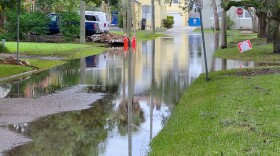
 Prepping for hurricane season starts with knowing your risks. Hurricanes are much more than just a coastal problem, so knowing what types of water and wind hazards could happen where you live is critical to your safety.
 -
 The study by the Pacific Northwest National Laboratory found warming waters in the eastern Pacific that produce winds that steer hurricanes are likely to shift toward the southeast U.S. and Gulf coasts.
 -
 The National Hurricane Center said in an update of its products that two-day outlooks will still be available in addition to the new seven-day outlook.
 -
 The massive storm is predicted to slam and soak Jacksonville as soon as Wednesday with heavy rain and the potential of flooding.
 -
 The storm is expected to produce periods of heavy rain, along with dangerous surf and possible beach erosion.
 -
 Fiona appears unlikely to threaten Florida, but winds could reach 74 mph by the time the system turns north toward the Bahamas next week.
 -
 Tropical Depression Seven formed Wednesday morning and is forecast to grow into a tropical storm. After that, wind shear and dry air could keep it from strengthening.
 -
 The lull we've experienced so far is not unusual. Tropical development will become increasingly possible around mid-August.
 -
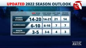
 “Not anywhere in the past have we had six consecutive seasons above normal,” said Matthew Rosencrans, NOAA’s lead for the seasonal hurricane outlook
 -
 Four in 10 Floridians surveyed by the AAA auto club said gas prices might keep them from leaving. The news came as forecasters suggested a potential storm in the Gulf could track toward Florida.
Play Live Radio
Next Up:
0:00
0:00
Available On Air Stations


