-
 Rainfall averaged 7.03 inches in March across the St. Johns River Water Management District — almost twice as much rain as normal.
 -
Another storm system is taking aim at the Panhandle and North and Central Florida.
-
 A line of severe storms is expected to push through the Panhandle on Tuesday night, and North and Central Florida on Wednesday. Damaging winds, large hail and a few tornadoes will be possible from the strongest storms.
 -
 A dynamic weather system this week will bring multiple days of potentially damaging winds, tornadoes and localized flash flooding.
 -
 Average February temperatures in Jacksonville sit 4.3 degrees higher than they were half a century ago. Scientists blame climate change.
 -
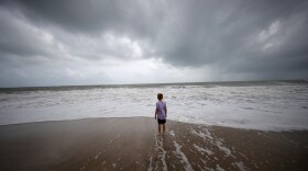
 A low pressure system developing over waters off the coast of Northeast Florida could push water up onto the shore, potentially causing flooding along the First Coast.
 -
 The calendar officially reads late February, but the Sunshine State will feel more like early May in the days ahead as temperatures reach through the 80s.
 -
 A powerful area of low pressure will usher in a cold front Tuesday. Strong thunderstorms are possible, along with the potential for a brief tornado or damaging winds.
 -
 A strong cold front will sweep through the Sunshine State by midweek, bringing the coldest temperatures of the season with it.
 -
 Gusty winds and widespread rain are anticipated over much of the state Friday into Saturday. Coastal flooding is also likely along a portion of the Atlantic coast.
Play Live Radio
Next Up:
0:00
0:00
Available On Air Stations


