-
 Ian remains forecasted to parallel the Gulf Coast before making landfall with the Sun Coast Thursday. Tornado risk increases from I-4 south today.
 -
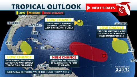 Four areas of tropical development are now being monitored in the Atlantic basin. The most concerning is a large area of low pressure over the central parts where organization into a tropical depression is likely by the middle of the week.


-
 The first tropical storm of the year may be forming in the Atlantic, even though the Atlantic Hurricane Season doesn't officially start until June 1....
 -
 Thunderstorms capable of producing wind damage, hail, or even an isolated tornado are possible across portions of north and central Florida Monday. The...
 -
Thunderstorms capable of producing wind damage, hail, or even an isolated tornado are possible across portions of north and central Florida Monday. The...
-
Thunderstorms capable of producing wind damage, hail, or even an isolated tornado are possible across portions of north and central Florida Monday. The...
-
Severe thunderstorms capable of producing wind damage and hail are possible Monday afternoon from Melbourne to Miami. The stronger cells will be capable...
-
A non-tropical disturbance is expected to approach Florida Thursday and Friday, producing summer-like downpours and thunderstorms across much of the...
-
Wind damage or a tornado is possible in the Florida Panhandle Thursday evening, then again on Friday across portions of the peninsula thanks to another...
-
Update 3:45 PM: Severe Thunderstorm Watch is in effect until 10 PM for Orlando, Fort Myers, West Palm Beach, and the Vero Beach area, and surrounding...
-
A dangerous squall line of thunderstorms is expected to approach the Florida Panhandle Thursday night, then sweep across the entire Florida Peninsula...
-
Thunderstorms capable of producing minor wind damage, or even an isolated tornado, are possible across the Florida peninsula today. The storms will be...

