-
 Ian remains forecasted to parallel the Gulf Coast before making landfall with the Sun Coast Thursday. Tornado risk increases from I-4 south today.
 -
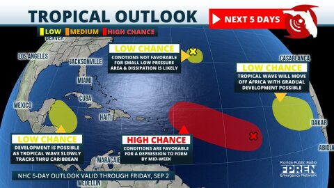 Four areas of tropical development are now being monitored in the Atlantic basin. The most concerning is a large area of low pressure over the central parts where organization into a tropical depression is likely by the middle of the week.


-
Fewer hurricanes are expected this year than the last two seasons, according to renowned researcher Dr. Phil Klotzbach of Colorado State University....
-
The weather is fooling many Floridians today, and it's not just a mean joke. A strong cold front has moved into the Sunshine State, producing rain and...
-
Winter has made a comeback in Florida. Freeze Warnings have been issued from Jacksonville to Pensacola, and a Wind Chill Advisory is in effect tonight...
-
A fast-moving storm system could produce severe thunderstorms in portions of the Florida Panhandle Sunday afternoon and evening. The strongest...
-
A fast-moving storm system could produce severe thunderstorms in portions of the Florida Panhandle Sunday afternoon and evening. The strongest...
-
A fast-moving storm system could produce severe thunderstorms in portions of the Florida Panhandle Sunday afternoon and evening. The strongest...
-
A complex of showers and thunderstorms is likely to produce heavy rain and gusty winds across portions of central Florida Wednesday afternoon and...
-
More than 50 record highs have been set in Florida this month, but that will come to an end this week thanks to a shift in the upper-level winds and...
-
Scientists at NOAA's Climate Prediction Center have officially declared an El Niño, and it may already be influencing the weather patterns over Florida....
-
A few strong thunderstorms are possible across the Florida Panhandle Wednesday evening, then across portions of the peninsula early Thursday morning. A...