-
 Ian remains forecasted to parallel the Gulf Coast before making landfall with the Sun Coast Thursday. Tornado risk increases from I-4 south today.
 -
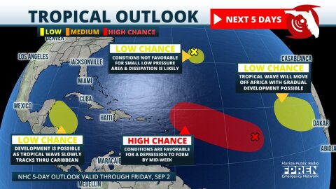 Four areas of tropical development are now being monitored in the Atlantic basin. The most concerning is a large area of low pressure over the central parts where organization into a tropical depression is likely by the middle of the week.


-
 Record-breaking warmth experienced this week in Florida is likely to be replaced by colder-than-normal temperatures early next week. Multiple freezes...
 -
 More than a dozen warm weather records have been tied or broken in Florida over the past three days, and the unusual warmth is expected to continue...
 -
 A Tornado Watch has been issued by the National Weather Service for Pensacola and surrounding areas of the Florida Panhandle until 4 pm Central time....
 -
 Forecast data continues to suggest a line of destructive thunderstorms will move through portions of the Florida Panhandle Saturday. Confidence is also...
 -
 A line of strong thunderstorms capable of producing destructive winds or a tornado is expected to move through the Florida Panhandle Saturday. In...
 -
 A few strong thunderstorms are possible tonight into Friday in advance of a strong cold front moving through the Gulf coast states. Humid, unstable air...
 -
 A narrow pocket of heavy rain is likely over South Florida Friday into Saturday thanks to high levels of moisture streaming in from the Atlantic Ocean....
 -
 A strong storm system moving in from the Gulf of Mexico is expected to send clusters of strong thunderstorms across portions of South Florida Sunday...
 -
 A soaking rain is likely across the Sunshine State Sunday, and it could be heavy enough to cause river or street flooding in some areas. Thunderstorms...
 -
 An interesting weather system may develop near Florida this weekend, and it has the potential to wash away your outdoor plans. There is also a chance it...


