-
 Ian remains forecasted to parallel the Gulf Coast before making landfall with the Sun Coast Thursday. Tornado risk increases from I-4 south today.
 -
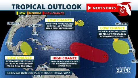 Four areas of tropical development are now being monitored in the Atlantic basin. The most concerning is a large area of low pressure over the central parts where organization into a tropical depression is likely by the middle of the week.


-
 The storm responsible for more than three dozen tornado reports across Louisiana, Mississippi, and Alabama on Monday is now moving through the Sunshine...
 -
 The National Weather Service has issued a Tornado Watch until 2 PM for much of the Florida Big Bend and portions of the Panhandle. The Tornado Watch...
 -
 A strong storm system is expected to bring tornadoes, hail, and damaging winds to portions of Louisiana, Mississippi, and Alabama Monday afternoon. It...
 -
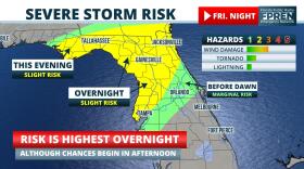 The risk of wind damage and possibly a tornado is increasing across portions of Florida Friday night. Multiple rounds of showers and thunderstorms are...
 -
The risk of wind damage and possibly a tornado is increasing across portions of Florida Friday night. Multiple rounds of showers and thunderstorms are...
-
 Widespread rain and a few strong thunderstorms are likely on Friday over much of the Big Bend, North, and Central Florida. The strongest storms may...
 -
 A sharp cold front moving through the state may bring the season’s first frost and freeze to parts of North Florida Tuesday and Wednesday mornings....
 -
 The last six months were filled with multiple threats and one very close catastrophe, but Floridians can now breathe a collective sigh of relief that...
 -
 Persistent onshore winds and high astronomical tides are likely to cause areas of coastal flooding for the rest of the week, particularly along Florida...
 -
 The season’s first freeze is likely tonight in the Florida Panhandle, and subfreezing wind chills are possible across portions of North Florida...


